


You are here
G2. Local Greens
Could Santos be gearing up to sell Narrabri? New analysis casts further doubt on gas project’s viability
New analysis has raised fresh doubts over the viability of Santos' controversial Narrabri gas project, amid speculation that a project sale announcement will be made at the company’s Investor Briefing Day on Tuesday 26 May.
NYC Light Projections
Boycott The Bezos Met Gala at the crown of the Chrysler Building, Boycott The Bezos Met Gala with Laughing Bezos Image.
50th & I5 Seattle Bannering
Who Murdered Renee & Alex, Trump Did That!, & Impeach Convict Remove,Trump'sCorruptionBetraysUsAll,& More Science Less Fiction.
Recording of Missoula Data Center Panel Event
This panel discussion recorded on May 19 in Missoula, MT explored the data centers being proposed in Montana, including one in Bonner, what is at stake, and how we can organize to protect our communities and our future. Featuring Anne Hedges of MEIC, Barbara Chillcott of Western Environmental Law Center, and Amy Cilimburg of Climate …
The post Recording of Missoula Data Center Panel Event appeared first on Montana Environmental Information Center - MEIC.
ICYMI: Coalition proposes alternate plan to address state water needs
On Wednesday, a coalition of Tribal leaders and environmental organizations, including Restore the Delta, released the Water Renaissance Plan, a new roadmap to shift California away from expensive, unreliable water imports toward local, sustainable solutions that deliver affordable, reliable water supplies.
For decades, California has relied on moving water long distances across the state, harming ecosystems and leaving communities dependent on costly and increasingly unreliable supplies.
Barry Nelson of the Golden State Salmon Association told Northern California Public Media, “The Sacramento River has experienced in the last 20 years a 95 percent decline in wild spawning salmon, the salmon that are actually the backbone of salmon fishing. It’s the most important salmon river in California. That crash is because of excessive water diversions.”
The new plan lays out an alternative path focused on reducing reliance on imported water and costly boondoggles like the Delta Tunnel, while investing in resilient local supplies that protect both communities and ecosystems.
“It’s past time to focus our limited dollars on water infrastructure investments that are sustainable for both urban and rural farming communities, respect Tribal water and land uses, and will allow keystone species like salmon to recover,” said Barbara Barrigan-Parrilla, Executive Director at Restore the Delta. “We can create improved water supplies and restore the largest estuary on the West Coast.”
As Politico reported, speakers at the press conference unveiling the Renaissance Plan were united in opposition to both the Delta tunnel and Sites Reservoir, describing them as expensive, outdated strategies. Instead, advocates pointed to wastewater recycling, stormwater capture, and conservation as more sustainable alternatives, while emphasizing that restoring the Delta is essential to protecting ecosystems and ensuring long term water reliability.
Learn more about the Water Renaissance Plan here.
###
Oregon’s POWER Act is the first of its kind to protect Oregonians’ utility bills from data center growth
New legislation would freeze staff cuts at land management agencies
U.S. Representatives Joe Neguse of Colorado and Jared Huffman of California introduced a bill to halt potential layoffs at public land management agencies through fiscal year 2030.
The Public Lands Workforce Stability Act would reinstate a moratorium on layoffs that expired earlier this year for the Interior department and the U.S. Forest Service.
Neguse and Huffman note that the Trump administration’s firings, buyouts, and early retirements have created staffing shortfalls on public lands. The Interior department has lost 25 percent of its workforce since the start of 2025, and the Forest Service has lost about 16 percent.
“At a time when our public lands and nearby communities are struggling with water, climate, and wildfire crises, we cannot afford to lose any more expertise,” Huffman, ranking member of the House Natural Resources Committee, said in a statement.
How a private billionaires’ club took over the Crazy Mountains
In the latest episode of The Landscape podcast, Floodlight News reporter Evan Simon joins Aaron and Kate to break down a controversial Forest Service land swap in Montana’s Crazy Mountains that quietly gave the owners of the Yellowstone Club—a private club for billionaires—near-exclusive access to what should be public land, and how Interior Secretary Doug Burgum’s involvement in the club raises ethical concerns.
Quick hits Trump officials say they can build 250-foot arch without Congress’s approval Former NPS officials push back on Big Bend border plans Lawmakers swore the Boundary Waters vote wasn’t about greenlighting a mine. Their actions say otherwise Underground coal fire in Colorado prompts emergency wildfire prevention project Lawmakers look to freeze staff cuts at land management agencies Federal agencies share ideas for boosting veterans’ access to outdoor recreation on public lands National parks are struggling, summer crowds are coming Conservation groups, Forest Service add new public land near Yellowstone National Park Quote of the dayThis is your land. Your wilderness. Your water. And they’re handing it to a Chilean mining company that paid a former cabinet secretary $380,000 to make sure they could take your copper and ship it to China.”
—Jim Pattiz, filmmaker and conservationist, on the Boundary Waters Canoe Area Wilderness, More Than Just Parks
Picture This @nationalparkserviceWhen you reappear in people’s lives after inexplicably disappearing for several months…
Spring and early summer are periods of increased bear activity in many parks. Bears may be moving through habitat, asking about your car’s extended warranty, searching for food or protecting cubs. Visitors can reduce the chance of a dangerous encounter by staying alert, hiking in groups, making noise in low-visibility areas, not talking about your car warranty, storing food and trash properly and never approaching bears.
Visitors should check current park alerts before their trip and follow park-specific bear safety guidance. Bear species, terrain, food storage rules and bear spray recommendations can vary across parks.
Learn more ways to stay safe around bears at: NPS.gov
(Featured image: A Bureau of Land Management employee in the Johnson Valley OHV Area, California. Photo by Jesse Pluim, BLM; Flickr)
The post New legislation would freeze staff cuts at land management agencies appeared first on Center for Western Priorities.
PUC Policy on Data Centers a First Step in Protecting Pennsylvanians but Regulations and Clean Energy Are Needed
(May 22, 2026) — Last Wednesday, the Pennsylvania Public Utility Commission (PUC) released its final large load model tariff that guides utility companies on how to handle large data centers. Hyperscale data centers will consume unprecedently large amounts of electricity, which makes them “large load” customers for utility companies.
This anticipated high electricity consumption is driving the need for significant grid upgrades and increasing energy demand, both of which raise energy costs for everyone. This PUC policy is a critical first step toward better protecting Pennsylvanians from shouldering the cost of large-scale data center development.
At a time when our lawmakers are scrambling to catch up to data center growth and energy demand, the PUC’s forward-thinking policy outlines certain standards that, if adopted by utilities, can improve transparency, better support low-income customers, and prevent infrastructure costs incurred for data centers from shifting onto everyday residents and small businesses.
These guidelines are an important step, but the PUC failed to act on key clean energy and reliability issues in this policy. Pennsylvania is at a crossroads where, without proper policy and regulations, data center buildout will create more fossil fuel generation, and lock in a future of environmental, climate, and public health harms.
Despite this, the PUC evaded any recommendation for data centers to bring their own clean energy sources online, which would both improve grid reliability and avoid emitting pollution. Similarly, the PUC failed to address whether data centers should interrupt or reduce their energy usage during periods of high energy demand.
The PUC does not yet have the authority to directly regulate data centers and set binding requirements, so these guidelines are only effective if the utilities choose to adopt them in their future rate proceedings. Currently, there is proposed legislation that, if passed, would direct the PUC to create binding regulations for data centers.
“Pennsylvanians are already paying for data center buildout through increased energy costs,” Alex Bomstein, Executive Director of Clean Air Council, said. “Until our decisionmakers take real, binding steps toward strong regulations on data centers, Pennsylvanians will continue to bear the burden of rising energy costs.”
Bomstein pointed out that the PUC’s large load model tariff sets a floor for how utility companies should think about their requirements to ensure data centers pay their fair share, but it misses the opportunity to provide guidance on the importance of clean energy in this conversation.
“It is critical that lawmakers and regulators act swiftly to build on this foundation and pass policies that will provide meaningful protections from rising energy costs due to data centers,” Bomstein said.
Botanical Gems Hiding in Plain Sight: Submerged Plants of River Estuaries and Lagoons
by Peter Baye
published in the July & September, 2017 issues of The Calypso, newsletter of the
Dorothy King Young Chapter of the California Native Plant Society
reprinted with permission
Last April (2017), our local public radio station (KZYX) ran an excellent “Ecology Hour” program interviewing world-renowned oceanographer John Largier from University of California, Davis Bodega Marine Lab. Marginal to the discussion of the physical processes that influence the Mendocino Coast river estuaries was a reference by some callers and hosts, to “algae” in the river.
That was an unintended cue for this botanical gem column on the trio of native submerged aquatic vascular plants that variably dominate our estuarine rivers. They are not algae themselves, but can become covered by algae at some stages, and at a distance, are mistakenly identified as nuisance algal blooms. Nothing could be farther from the truth, since native submerged aquatic vegetation (SAV) beds are the standard of high estuarine habitat quality sought all over the world – qualifying as both ecological and botanical gems. But aquatic plants species, especially submersed species that complete their life-cycles under water, are also out of sight and thus out of mind for many observers. They are thus easily mistaken, by prejudice, for algae when visible at the water surface. That prejudice can lead to misguided demands for getting rid of falsely perceived “nuisance” algae.
So before we have to defend our pristine native SAV beds, let’s introduce two of a trio of revered dominant underwater plant species that cohabit Mendocino Coast river estuaries: wigeongrass, Ruppia cirrhosa and sago pondweed, Stuckenia pectinata (syn. Potamogeton pectinatus). The linear-leaved eelgrass, Zostera marina is the third species and it will be discussed in the Sept-Oct, 2017 issue of the Calypso. [below] Thick beds of wigeongrass, Ruppia cirrhosa, mantle upstream brackish reaches of the fully tidal Albion River estuary. Long frond- like shoots sway back and forth with each ebb and flood tide. July 1, 2017
WIGEONGRASS, Ruppia cirrhosa, is the most widespread and abundant of Mendocino’s estuarine SAV species: it occurs in every estuary, whether fully tidal or summer lagoon, in DKY’s [Dorothy King Young Chapter of the California Native Plant Society] territory. In some rivers, like Navarro, Albion and Big Rivers, it extends for miles. That fact makes it all the more astonishing that the genus doesn’t even appear in the Mendocino Flora (Smith & Wheeler 1992), and there are no reported herbarium or checklist records of it from Mendocino in the Consortium of California Herbaria or Calflora databases! There isn’t even a record of its close relative (even a synonym in some taxonomic treatments of Ruppia), R. maritima. “Underrepresented” is an understatement for this botanical omission – the estuarine equivalent of omitting redwoods from the Mendocino flora.
Emergent erect spike of Ruppia cirrhosa, on still water of Navarro River lagoon. July 18 2013Our estuarine riverbed wigeongrass consistently produces long, wiry coiled peduncles, which is the diagnostic characteristic for Ruppia cirrhosa. R. maritima is the typical wigeongrass in salt marsh pools worldwide, which are shallow, warm, and more saline than seawater. Contrary to some descriptions of Ruppia, the male inflorescences of our R. cirrhosa often form erect spikes that emerge above the water surface, and release masses of pollen that make a whitish film on the water that winds can blow into piles of decaying scum in late summer.
Ruppia cirrhosa mats drape over limbs of downed alders as the Navarro River lagoon draws down in summer. July 18, 2013Wigeongrass is a stealthy plant: when it grows underwater, it is barely detectable. When the fronds reach just below the water surface, they branch and proliferate, and drag on the water surface, heralding themselves by flat water surface areas, outlined by wind-waves and ripples around them where there is no wigeongrass. Finally, the fine linear leafy branches expand into floating mats that completely cover the water surface. Ducks and geese push through the floating mats as they feed on the leaves and invertebrates that live in them, leaving trails. Steelhead jump all around the food-rich wigeongrass canopies at dusk and stickleback move in abundance under the canopies themselves. During heat waves, stickleback fish kills occur when the dense tangled floating mat interior overheats, and stickleback can’t escape in time.
Sandpipers foraging on a thick floating Ruppia cirrhosa mat on the lagoon of Navarro River. August 6, 2016Wigeongrass grows from perennial rhizomes, but it also colonizes new substrate very rapidly by seed and by vegetative propagules. Unlike eelgrass and sago pondweed, it regularly colonizes gravel estuarine river beds like an annual, apparently from seed. In late summer, it spreads over sandy bottoms near the river mouth by creeping rhizomes and stolons, forming prostrate turf across the bed, which later develops vertical shoots. It even can form unusual short zig-zag lateral branches with pre-formed short anchor roots, which readily detach, disperse and sink to the bed as instant, ready-to-grow vegetative propagules.
Wigeongrass can grow in both seawater and fresh water, and appears to tolerate switching back and forth. The primary production of wigeongrass in our estuaries is huge. So is the density of shoots under the floating mats: a single hand-grab of a tangled shoot mass can be heavier than a person can lift out of the water.
SAGO PONDWEED, Stuckenia pectinata (syn. Potamogeton pectinatus), is another nearly cosmopolitan aquatic plant species. It has less salt tolerance than wigeongrass, usually occurring in freshwater or fresh-brackish water.
Flowering and fruiting spikes on floating mat of sago pondweed, Stuckenia pectinata, Navarro River lagoon (closed nontidal freshwater estuary phase). July 18, 2013Salinity about half seawater strength (3.5 % salinity, 35 ppt) is enough to severely inhibit its growth or kill it. Sago pondweed has similar fish and estuarine invertebrate food-chain support value as wigeongrass, but it has even more food value for dabbling ducks and diving ducks. The fruits (drupes) and pea-sized, seed-like vegetative propagules it forms in fall (turions; overwintering detached “buds”), as well as its rhizomes, are eagerly consumed by waterfowl. The foliage is also consumed. Sago pondweed colonies in our river estuaries are usually patchy, far less extensive than wigeongrass. But they can also rebound in “boom” years and actually overtop and surprisingly replace dominance by wigeongrass over extensive areas, at least temporarily.
Flowering spikes of Stuckenia pectinata with anthers. July 2013
Wigeongrass can be distinguished from sago pondweed easily when they are flowering or in fruit. Sago pondweed has thick, elastic peduncles terminating in spikes with whorls of flowers or swollen brown, nearly round drupes. Wigeongrass has slender-peduncled inflorescences (wiry and coiled in R. cirrhosa), terminating in 3 or more terminal branchets with asymmetric pointed fruits, or a short spike of whitish male flowers (mostly anthers). Vegetatively, both species have very narrow linear leaves, but wigeongrass has tiny teeth along the blade margins, and long sheaths that pull themselves away from the shoot, at their bases. Sago pondweed sheaths enclose their stems tightly, like a tube with overlapping margins where they enfold the stem. Sago pondweed is far more difficult to distinguish from linear-leaved pondweeds in the genus Potamogeton, in which it was traditionally placed as P. pectinata.
W.L. Jepson was so enamored of sago pondweed as a waterfowl food in early historic Suisun Marsh (San Francisco Estuary) that he wrote a popular article about his first-hand observations for Sunset Magazine, “Where Ducks Dine”, in 1905. (yes, it’s found online!). When canvasback ducks can’t feed on sago, which makes their flesh sweet and nutty, they eat clams that make their meat taste fishy and gamy. Canvasback hunting has lost popularity as sago pondweed wetlands have declined in California.
Fully elongated fruiting spike of Stuckenia pectinata. August 2011Sago pondweed is reported in the Mendocino County flora from inland ponds, but only one coastal pond complex (Hunter Lagoon and Davis Lake, Manchester) and two estuaries: Pudding Creek (above the dam, however) and Big River. In fact, it is intermittently abundant and extensive at Ten Mile River, near the head of navigation on Albion River, and in the Navarro, Garcia (P’dhau), and Gualala estuaries.
There are basically three types of coastal river estuaries in Mendocino County that predict the location and mix of our native SAV plant species composition. Perennial tidal estuaries, intermediate (choked) tidal estuaries, and seasonal estuaries forming non-tidal summer lagoons.
Perennial fully tidal estuaries include the Albion River and Big River. Their mouths are sheltered from Pacific swell and large coarse-grained barrier beaches by rocky headlands that form quiet embayments, keeping their mouths from closing (by barrier beaches) or choking up with sand. Fully tidal estuarine rivers are home to a gradient of all three species. Ten Mile River estuary is usually tidal all year, but with flows that can become choked and reduced when the barrier beach and shoals grow across the mouth in summer.
Floating, fruiting canopy of Stuckenia pectinata over a bed surrounding the riparian woodland and marsh island above the mouth of Navarro RiverThe Gualala and Navarro River Estuaries, in contrast, are usually tidal only when river flows force their high coarse-grained barrier beaches to breach and open a tidal inlet. When freshwater flows diminish in spring or summer, the tidal inlets close, and form deep freshwater to fresh-brackish lagoons (saltier at the bottom; “stratified”), with water levels well above high tide. Eelgrass cannot compete or survive in non-tidal brackish to freshwater lagoons, but wigeongrass and sago pondweed can thrive in them, and do.
In all three estuary types, a highly variable mix of wigeongrass and sago pondweed beds occur. They dominate tidal estuaries in their more brackish to freshwater tidal river reaches, overlapping with eelgrass, but dominating above the upstream reach of eelgrass. In non-tidal summer lagoons, wigeongrass and sago pondweed vary greatly in relative abundance and position, with a mix of persistent old perennial beds, and rapid new colonization responding to changed estuary conditions.
The next time you drive over one of the Mendocino County estuaries on Highway 1, and see “algae”, think about running down to the shore and looking for beached samples of one of our native SAV species. And if you overhear discussion of “algal blooms” in our estuaries, help educate about what native vascular plant species lie underneath and attached to those epiphytic algal mats, and what they indicate about environmental health and water quality. This region is an estuarine sanctuary compared with most of the California Coast, and we can boast of some of the most healthy, beautiful and diverse estuarine SAV in the state.
Part 2 – Eelgrass, Zostera marinaOf the three submerged aquatic plants occurring in coastal Mendocino and Sonoma counties, eelgrass, Zostera marina, is a true seagrass that occurs in soft sediments (mud or sand) of fully tidal bays and estuaries with high transparency, allowing light to penetrate to the bottom. Wigeongrass (Ruppia cirrhosa), and sago pondweed (Stuckenia pectinata, syn. Potamogeton pectinatus), the two other estuarine species in our area, were treated in Part 1, July-August, 2017 issue of the Calypso. [above] Zostera marina at low tide, lower Albion River estuary, on rising tide with seawater flooding into the estuary. Unidentified marine algae grow as epiphytes on the blades. July 1, 2017.
It has flat, broad linear grass-like blades on long, supple flexuous shoots that sway with tidal currents. Like all seagrasses (marine flowering plants), it completes its life-cycle in seawater, flowering, fruiting and establishing from seed or clonal (vegetative) growth under water. It can grow in the lower intertidal zone, but it flourishes in shallow subtidal water, especially in cohesive muddy or sandy mud sediments where its rhizomes can anchor. In tidal rivers, it has to be able to tolerate full marine salinity seawater on rising (flood) tides, but also freshwater pulses on low tides in winter when river discharge is high.
The floating canopy of Zostera marina beds a half mile upstream from the mouth of the Albion River, Aug 6, 2014. Little epiphytic algae grows on the blades some drought yearsEelgrass beds provide ecologically important fish habitat: nurseries and foraging (feeding) habitat for small estuarine fish (including anadromous salmon and steelhead) that move through their canopies or feed around their edges, where they have access to visual cover from predators. They also help bind and stabilize sediment and store carbon in sediments. In the Ten Mile estuary, eelgrass canopies are crawling with juvenile Dungeness crabs in spring some years, moving up-estuary on flood tides. Waterfowl, especially brant, consume the shoots.
Zostera marina canopy floating at the water surface, vertical shoots rising in the water column below. Big River July 18, 2012.In summer, eelgrass leaves develop epiphytic algae: marine or estuarine algae that grow on their leaves. Heavy covering of algae on eelgrass can trigger seasonal decline or even seasonal dieback, especially when temperatures warm in choked, brackish tidal estuaries. Turbid water, due to either suspended mud or algae, also can cause eelgrass decline by reducing light penetration in the water. Eelgrass thrives best in transparent cool, saline water with daily tidal flows and strong tidal circulation.
Zostera marina growing upstream of its usual limits, mixed with Ruppia cirrhosa in brackish tidally choked estuarine conditions, upstream of Hwy 1 bridge, during a major drought with low freshwater river outflows. Aug 14, 2015Our native estuarine SAV dominant plants are grossly under-documented. It is particularly remarkable that the robust, extensive eelgrass beds of the Albion estuaries have escaped the attention of researchers and our state and federal resource agencies, as well as our floristic database records. There is only one reported Mendocino County locality of the species, Big River, in Calflora and Consortium of California Herbaria. There are no botanical records of the magnificent Albion eelgrass beds, or the highly elastic Ten Mile River eelgrass beds that vary between mile and mere yards long.
Zostera marina colonizes our tidal estuarine river beds upstream during droughts, following seawater mixing – salinity – gradients. A new colony is growing here in an upstream reach under freshwater willow swamp drought year, Ten Mile River, 2013Eelgrass occurs only in tidal estuary (daily tidal flows) reaches where seawater influence is strong, at least during flood tides that deliver salty, clear water.
There are basically three types of coastal river estuaries in Mendocino County: perennial tidal estuaries, intermediate (choked) tidal estuaries, and seasonal estuaries forming non-tidal summer lagoons. Perennial fully tidal estuaries include the Albion River and Big River. Their mouths are sheltered from Pacific swell and large coarse-grained barrier beaches by rocky headlands that form quiet embayments, keeping their mouths from closing (by barrier beaches) or choking up with sand. Fully tidal estuarine rivers are home to a gradient of all three species.
Zostera marina beds grow in a distinct zone the tidal channel below brackish tidal marsh, Big River. Sept 6, 2014Eelgrass occurs in these fully tidal estuary (daily tidal flows) reaches where seawater influence is strong, at least during flood tides that deliver salty, clear water. Eelgrass also occurs in our choked, intermediate tidal estuary, Ten Mile River. Ten Mile River estuary is usually tidal all year, but with flows that can become choked and reduced when the barrier beach and shoals grow across the mouth in summer. The Garcia River is also subject to choked tides, but its mobile gravel bed all the way to the mouth seems to exclude stable eelgrass.
This year, unexpectedly, the Navarro River mouth sustained an open tidal inlet through the summer, and changed from its normal freshwater above-tide lagoon condition, to a tidal brackish estuary that could support eelgrass if the unprecedented tidal lagoon condition returns in future summers. Is this unprecedented event a random fluke, or a harbinger of the future? Could eelgrass expand its range in Mendocino County as sea level rises and climate changes? Eelgrass and its associated Mendocino lagoon/estuary aquatic plants should be informative “sentinel” species for climate change here.
All photos by Peter Baye
For more information, see:
Gualala Estuary: Native Aquatic Vegetation versus Algal Blooms
Water, energy, land use: Missoula data center proposal prompts questions
By: Katie Fairbanks, Montana Free Press As nationwide opposition to the increasing number of data centers grows, a crowd of more than 100 people gathered at the University of Montana Tuesday for a panel discussion about the facilities proposed in the state, including one in Missoula’s backyard. Panelists from environmental groups detailed the potential effects …
The post Water, energy, land use: Missoula data center proposal prompts questions appeared first on Montana Environmental Information Center - MEIC.
‘We’ve never seen anything like this’: Groups warn of data centers at Missoula meeting
By: David Erickson, Missoulian Some have nicknamed it “Keystone Light.” But this fossil fuel pipeline, if it becomes a reality, would not be small by comparison. Representatives from four environmental nonprofits gave a presentation in Missoula on Tuesday night to sound the alarm bells about the harms that may come from data centers in Montana …
The post ‘We’ve never seen anything like this’: Groups warn of data centers at Missoula meeting appeared first on Montana Environmental Information Center - MEIC.
Powering Rural America: Broad Coalition Champions the Rural Energy for America Program
An Update on the Hole-in-the-Rock Road
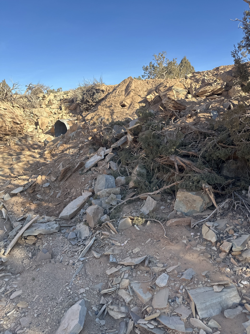
We’re disheartened to report that Garfield County has begun chip sealing (effectively paving) the first 10 miles of Hole-in-the-Rock Road within Grand Staircase-Escalante National Monument. Below we share some information about why this is happening—and why our fight to preserve the character of this rugged backroad at the heart of the monument matters.
Hole-in-the-Rock Road runs from the junction of Highway 12, east of the town of Escalante, to the top of the cliffs above the Colorado River within the Glen Canyon National Recreation Area; it provides access to popular destinations like Spooky and Peek-A-Boo slot canyons, Devil’s Garden, and Coyote Gulch. Surrounded by wilderness-quality lands, 57 of the road’s 62 miles are within the monument (the remaining are in the recreation area) and 16 miles are in Garfield County. It is an unpaved, primarily dirt road that is core to the remote experience that defines the monument.
In February, SUWA filed a lawsuit in federal court, alleging that Garfield County and the Bureau of Land Management (BLM) violated federal law when the county began making unauthorized “improvements” to the road. While Garfield County has title to a right-of-way for the road, it does not own the road or the land beneath it (this remains federal public land) and it cannot lawfully take unilateral action to improve the road. Instead, the county is required to consult with the BLM before making any improvements, such as widening or realigning the road, installing new culverts, or chip sealing the surface.
The BLM, for its part, is required by law to protect the things that make the monument so special, and to make sure that activities like these do not cause unnecessary damage to public lands. Sadly, the agency entirely failed in those duties, idly standing by while the county conducted weeks of unauthorized work that will forever change the character of this area.
When SUWA learned that the BLM had completed its consultation for the chip sealing and authorized the county to proceed, we immediately swung into action and sought a temporary restraining order from the court; late last Friday a federal judge denied our request. This week we’ve filed another motion seeking an emergency injunction to pause the county’s chip seal work. Meanwhile, the county is rushing to complete the paving before the court has a chance to rule on that motion.
Despite all of this, our pending case will continue to proceed in federal court on its merits, and we expect to prevail. But by then the changes to the road and damage to the monument will be done. Paving will lead to more, faster, and louder traffic, changing the remote, serene backcountry experience the monument was created to protect, and that draws visitors from around the world.
In the future, we hope to share more positive news. SUWA’s work to Protect Wild Utah and the national monument—which is also currently at risk—continues on, thanks to people like you. At SUWA we take the long view, and we firmly believe that these places are worth fighting for. If you’re able, please consider a donation to support SUWA’s work.
For Grand Staircase-Escalante,
Hanna Larsen & Steve Bloch
Staff Attorney & Legal Director
The post An Update on the Hole-in-the-Rock Road appeared first on Southern Utah Wilderness Alliance.
Lock the Gate seeks review of Queensland government’s approval of first stage of major gas expansion
The Lock the Gate Alliance has today requested an internal review of the Queensland government’s decision to approve a gas development, saying it failed to consider or mitigate human rights and environmental impacts when approving the first stage of a major gas expansion in the Western Downs region.
June 11 North Omaha Town Hall: Senators Terrell McKinney & Ashlei Spivey to Discuss Data Centers With Guest Jane Kleeb
Nebraska State Senators Terrell McKinney & Ashlei Spivey Invite You To Attend:
A NORTH OMAHA TOWN HALL MEETING
The town hall will feature the Senators’ work this past session and serve as an opportunity for the community to ask questions.
The town hall will also feature a discussion on LB 1111, a data center bill sponsored by Senators McKinney, Spivey and Machaela Cavanaugh, which was also supported by Bold Nebraska, that was incorporated in LB1010 and passed into law. The law holds data centers accountable and provides for transparency that no other state has been able to pass. Bold Founder Jane Kleeb will join the Senators for the data center discussion.
- WHEN: Thursday, June 11, 2026, 6:00 – 7:30 p.m.
- WHERE: Nelson Mandela Elementary School, 6316 N. 30th Street, Omaha, NE
- RSVP: Let us know you are coming!
*The event is free and open to the public. Refreshments will be provided.*
Bold’s Energy Builders Project provides education, training, legal, communications, and organizing support to rural communities that want to see more clean energy built in their towns. BoldEnergyBuilders.us
New California water coalition breaks with century-old playbook, releases “Water Renaissance” vision for the state’s water future
For Immediate Release
May 20, 2026
Contact
Nina Erlich-Williams, nina@publicgoodpr.com
O: 510-336-9566, C: 415-577-1153
Plan identifies specific strategies for developing drought-proof water supplies in SoCal by 2045 that will generate significantly higher yields than projections for the Delta Conveyance Project
Bay-Delta Region and Los Angeles, Calif. – In an online press conference today, leaders from conservation groups and Tribes announced the release of a Water Renaissance Plan for California. The plan lays out a vision, including specific goals and metrics, for prioritizing local water resilience in California’s urban areas – especially in Southern California – to support a pivot away from the state’s overreliance on unreliable imported water.
Among other findings, the plan identifies the opportunity to secure 1.8-2 million acre-feet of drought-proof water supplies in Southern California by 2045 through sustainable technologies like stormwater capture, wastewater recycling, conservation, and groundwater cleanup. The total cost for such investments would be approximately $44 billion. In comparison, the proposed Delta Conveyance Project is only projected to yield 0.4 million acre-feet of water annually at a likely cost upwards of $60 billion.
“Southern California water agencies are already turning toward projects that can provide reliable local water,” said Bruce Reznik, executive director of LA Waterkeeper. “These types of investments make our region more resilient. We should direct ratepayer and taxpayer dollars to securing water supplies that are available year in and year out, rain or shine.”
As shown in this fact sheet, the amount of water available for export from two of Southern California’s main sources of fresh water – the Bay-Delta and the Colorado River – is projected to drop by 23% and 29% respectively in the coming years, compared to available water in recent decades. The report argues that continuing to over-invest in infrastructure designed to pipe water over hundreds of miles is a risky strategy, especially as snowpack and rainfall patterns become less predictable due to climate change.
Water exporting regions are also feeling the strain of changing weather patterns. As has been widely reported, the Colorado River is at an all-time low since water exports began in the early 1900s. The Bay-Delta is on the verge of ecosystem collapse due to extensive water exports that support both Central Valley agriculture and urban uses in Southern California and Silicon Valley. In the Eastern Sierras, Mono Lake and Owens Lake are similarly struggling due to excessive exports to Los Angeles.
“Proposed projects like the Delta Tunnel would decimate ecosystems and communities throughout California,” added Restore the Delta executive director Barbara Barrigan-Parilla. “It’s past time to focus our limited dollars on water infrastructure investments that are sustainable for both urban and rural farming communities, respect Tribal water and land uses, and will allow keystone species like salmon to recover. We can create improved water supplies and restore the largest estuary on the West Coast.”
The Water Renaissance Plan includes eight priority recommendations:
· Direct state agencies to end planning and advocacy for the Delta Tunnel and instead adopt and enforce science-based instream flow protections for the Bay-Delta and its Tributaries.
· Consider pursuing an ambitious general obligation water bond that focuses on modern local water supplies and does not include wasteful or environmentally damaging spending.
· Develop best management practices and regulatory standards to address harmful algal blooms.
· Require the adoption of tribal beneficial uses so that tribal uses are recognized and protected in permitting decisions.
· Direct state officials to ensure Colorado River diversions are appropriately reduced as part of a basin-wide plan to ensure long-term sustainability and protect the environment, tribes, and urban water users.
· Create a framework for local businesses to fund green infrastructure for stormwater capture.
· Remove the cap on large water recycling projects for receiving loans from the State Revolving Fund and allocate sufficient funds to the SRF to meaningfully support large-scale projects.
· Reform Proposition 218 to allow for local water rate assistance programs and ensure aggressive conservation rates can be implemented.
The Plan also includes analysis and sources to support its vision. It was drafted jointly by the California Sportfishing Protection Alliance, Defenders of Wildlife, Friends of the River,Golden State Salmon Association, LA Waterkeeper, Resource Renewal Institute, Restore the Delta, San Francisco Baykeeper, Sierra Club California, Winnemem Wintu Tribe, andYosemite Rivers Alliance. As of May 19, 2026, 18 additional groups have endorsed the plan. For a full list of endorsers and additional information about the Water Renaissance Plan, see www.cawaterrenaissance.org.
###
Charlottesville VA Visability Brigade
Honor Vets Fight Fascism, ShameOnSCOTUS&HandsOffBlackVotes!
Pages
The Fine Print I:
Disclaimer: The views expressed on this site are not the official position of the IWW (or even the IWW’s EUC) unless otherwise indicated and do not necessarily represent the views of anyone but the author’s, nor should it be assumed that any of these authors automatically support the IWW or endorse any of its positions.
Further: the inclusion of a link on our site (other than the link to the main IWW site) does not imply endorsement by or an alliance with the IWW. These sites have been chosen by our members due to their perceived relevance to the IWW EUC and are included here for informational purposes only. If you have any suggestions or comments on any of the links included (or not included) above, please contact us.
The Fine Print II:
Fair Use Notice: The material on this site is provided for educational and informational purposes. It may contain copyrighted material the use of which has not always been specifically authorized by the copyright owner. It is being made available in an effort to advance the understanding of scientific, environmental, economic, social justice and human rights issues etc.
It is believed that this constitutes a 'fair use' of any such copyrighted material as provided for in section 107 of the US Copyright Law. In accordance with Title 17 U.S.C. Section 107, the material on this site is distributed without profit to those who have an interest in using the included information for research and educational purposes. If you wish to use copyrighted material from this site for purposes of your own that go beyond 'fair use', you must obtain permission from the copyright owner. The information on this site does not constitute legal or technical advice.